

LynxGeos custom map samples, using public GIS data:

Southwest Map
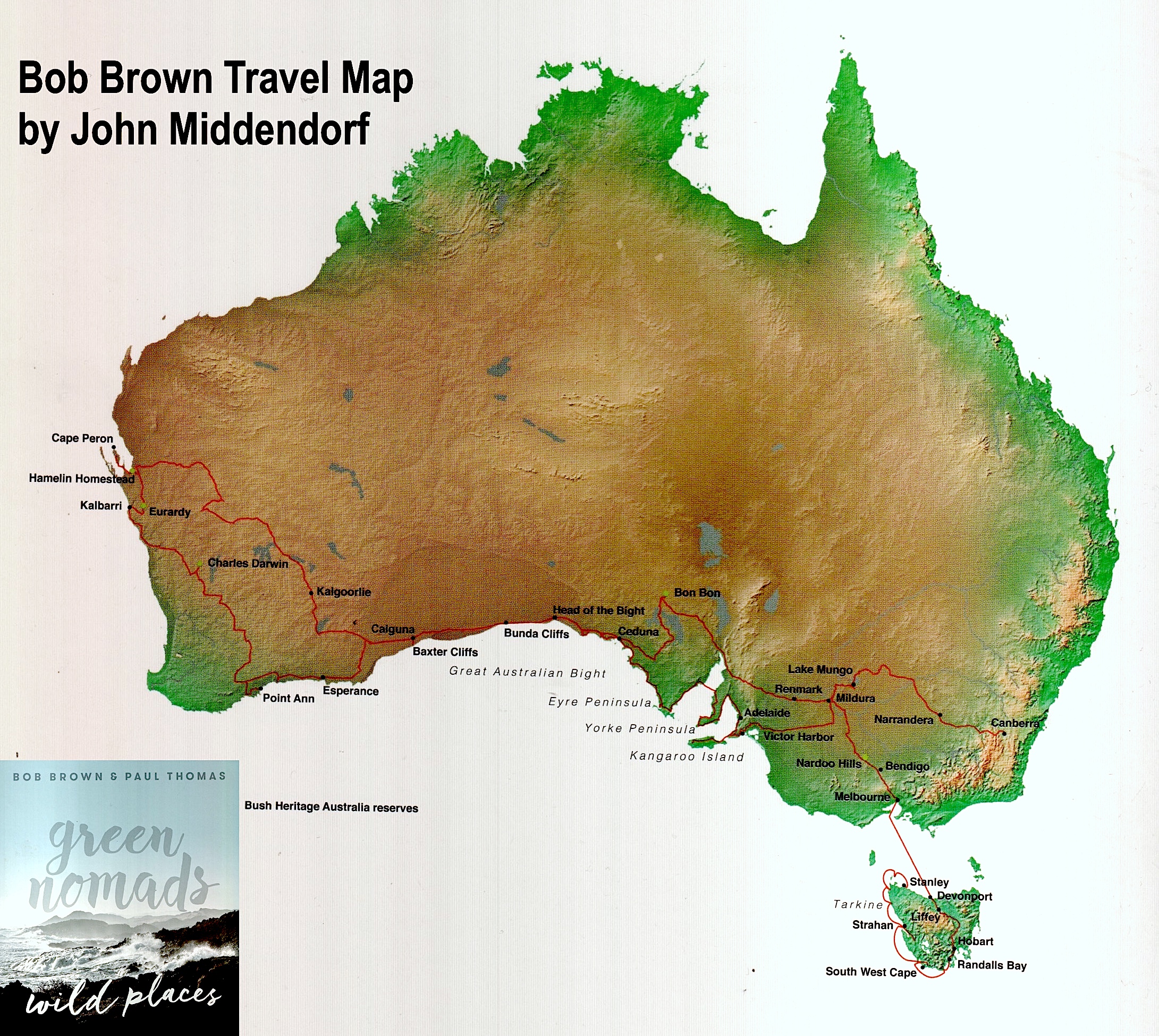
This map was created for Bob Brown's travel book, Green Nomads, Wild Places, and was featured in the opening pages of the book.
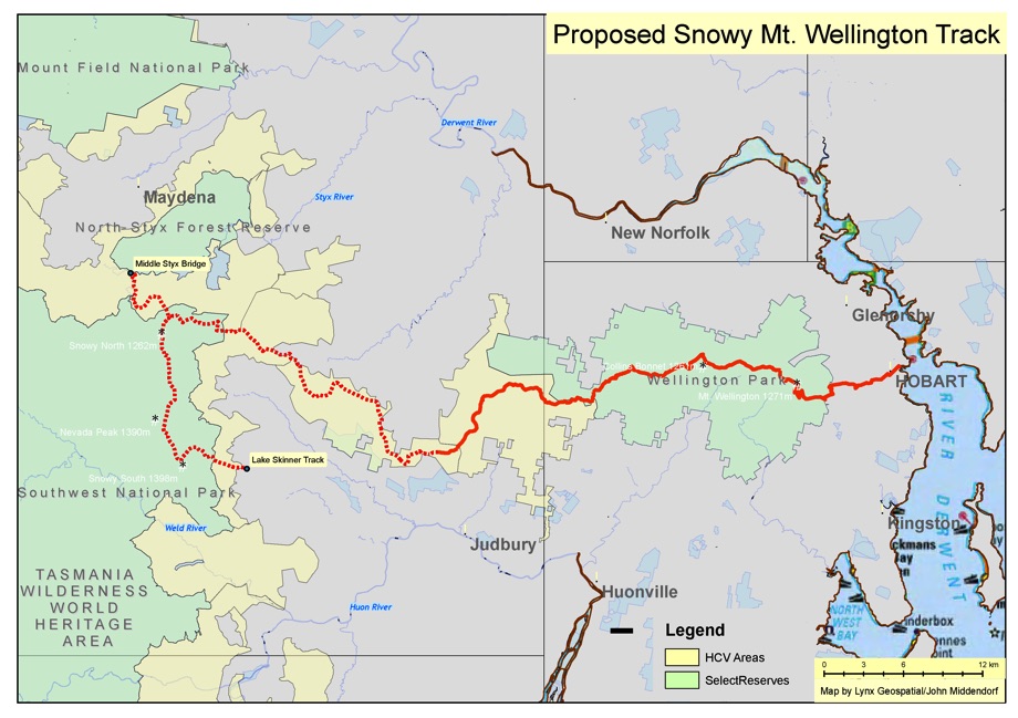
This map was created in Bob Brown's Hobart office working directly with Bob Brown. The goal was to establish another iconic Tasmania trail from Mt. Wellington to the Styx forest. The map was produced for both presentation to the Wellington Trust and for the Mercury newspaper.
You can download the KML file here (for use with Google Maps)
Lynx Geosystems has created an interactive online map for Environment Tasmania and the Wilderness Society showing their HCV (high conservation value) areas.
Note how this map shows “Polygons with Holes”, which required complex coding using the Google Map API. Lynx custom developed a custom Shapefile to Encoded Polyline converter specific for this task (see next entry).
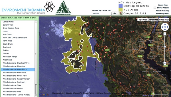
Recommendation from the Wilderness Society:
John Middendorf has exceptional skills at developing online maps as
well as excellent ideas about how to make the most of this technology.
The High Conservation Value Forest online interactive map John created
for the Wilderness Society has proved invaluable for allowing the
public to easily access and understand a large amount of complex data,
something that normally requires specialist skills and software. John’s
professionalism is evident in the presentation and elegant interface of
his work, and the attention to detail and accuracy. Furthermore, John
is efficient, reliable and a pleasure to work with.
Nick Fitzgerald
Wild Island Project Coordinator
The Wilderness Society (Tasmania) Inc.
CLICK HERE TO SEE HOW THE MAP WORKED
The Tasmanian Land Conservancy “revolves” properties, and required an interactive map that showd the complete details of each property, along with a map that shows the property boundaries and the properties relationship to surrounding conservation land. LynxGeos was chosen to implement their online “Map Search”.
LynxGeos also created a separate Online Interface for this solution, which allows the Tasmanian Land Conservancy to add/edit/delete properties that appear on the map. All data, as well as the map itself, is stored in the “Cloud”, so the map will respond quickly to all web requests, whether it has 100 or 100,000 simultaneous users.

Daniel at the TLC provided us with a glowing report:
Hi John – I’d like to thank you for your great work for our Revolving Fund, done in a timely fashion and at a good price.
Your interactive property map has helped us share information of
our properties in an elegant and easy to use way. It is simple to use,
yet displays a lot of complex information, including our properties
boundaries, in a speedy way. Best of all, it is a complete
standalone component of our website, and does not require any
maintenance or work by our IT department, yet I can add, edit, and
remove properties quickly using our custom admin interface.
Thanks so much for your help and all the best for your company.
Regards – Daniel
Daniel Sprod
Landscape Ecologist
Tasmanian Land Conservancy
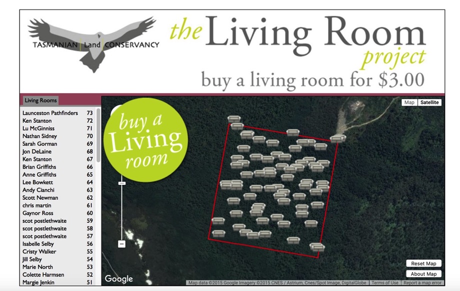
When the Tasmanian Land Conservancy wanted a fun, interactive fund raising web based map, LynxGeos created the Living Room Series. Donors could "buy" a living room on land protected by the TLC. The live interactivity of this site required careful coding! It was reported by Jane Hutchinson, CEO of the TLC, that the art curator David Walsh was impressed with the site during it's live opening in Hobart.
Another popular Open Source tool from Lynx Geos for use with Google Maps.

This tool will process complex shapefiles, and display polygons with holes, if there is an interior polygon. Showing polygons with holes is not a trivial feat with the Google Map API!

This map was created as a tool for the Tasmanian Land Conservancy to be able to quickly look up parcels in Tasmania. Using proprietary Lynx database algorithms and optimization, it is by far the fastest parcel search engine available, searching over 380,000 parcels in a few milliseconds. Compare this with Tasmania’s official parcel map, The List, which takes a second or two to retrieve each search request.
This interactive map was created for Still Wild Still Threatened and the Huon Environmental Group for a 24-hour protest they organised.It showed photos from around the world on a simultaneous global protest and was updated dynamically.

Lynx Geosystems has created many popular iPhone and Android Apps:
CalQuakes–an earthquake mapping application for California (over 20,000 downloads)

RockNRoad AZ–maps and information for all the climbing areas in Arizona

This was the first iPhone climbing guide with interactive map features.
Dreamtime–Australia Aborigine Art

Lynx Geosystems offers solutions to sync Real Estate Transaction Standard (RETS) servers with cloud servers on a daily basis. The product is Rets2Cloud, and is currently in use with the largest Real Estate Multiple Listing Services (MLS) in the country, including the Texas NTREIS.
The challenge provided by the Tasmanian Land Conservancy was to create an easy-to-update mapping system for an ever-changing selection of properties. The map is dynamically generated based on the contents of a “data folder”, consisting of spatial files (in Shapefile format), images, and text, so the map can be easily updated by the client simply by dropping new GIS Shapefile data files into the folder.
Lynx Geosystems is proud to offer a new tool for Cloud Database users: SQL2SDB, for syncing a SQL server with the Amazon Simple DB cloud database.
Features:
Visual IDX is the most advanced IDX in the world!

Lynx offers both simple and advanced IDX sites.

Note how our Streetview shows the direction on the main map.
LynxGeos can create custom, easy-to-use yet extremely powerful maps to enable efficient information services. The Lynx Parcel map for Archuleta County has been exceptionally popular, with over 40 clients. It is much quicker, more conveinient, and has additional features than the county map. The custom branding allows realtors to quickly create PDF’s of properties in Archuleta County.


LynxGeos can provide custom location maps for Realtors who desire to provide additional information to their clients. These were crafted to show the proximity of properties to public lands surrounding Pagosa.


LynxGeos can provide GIS services to create custom numbering of properties for sale for real estate guides.

The LynxGeos MLS interactive map system updates MLS information daily and presents the for-sale properties in a interactive powerful map. In just a few clicks, the user can bring up MLS information and photos, and print out a custom PDF complete with map and MLS information. The LynxGeos MLS map has unique patent pending features such as the parcel One-Click measuring tool, which provides lot line dimensions.


On-the-fly PDF creation…
A LynxGeos map for the Town of Pagosa Springs helps people find civic and public landmarks.

When the Town of Little Compton needed a map to describe basic GIS information to its residents, LynxGeos designed the interactive town map published on the town website. Like many counties and states, much of the public GIS iinformation is available, yet requires technical expertise to view in a software program. LynxGeos specializes in creating quick yet powerful easy-to-use interfaces to allow full querying of complex data.

LynxGeos creates black and white maps for newspapers to accompany and illustrate news stories. To provide graphical and spatial information without colors is an added challenge.
